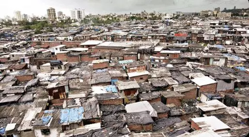
Drones, LiDAR put in use to map Asia's largest slum redevelopment project

Mumbai: In a first for any slum rehabilitation project in India, the Dharavi Redevelopment Project (DRP) has embraced cutting-edge technologies to survey and document Asia's largest slum, officials said. Drones and remote sensing technology Light Detection and Ranging (LiDAR) are being used to map the 620 acres densely populated Dharavi slums. This is to ensure accuracy, transparency, and efficiency in a redevelopment project of this scale and complexity.
The Dharavi Redevelopment Project Pvt Ltd, in which the Adani Group holds an 80 per cent stake along with the state government, plans to turn 620 acres of prime land, about three-quarters of the size of New York's Central Park, into a glitzy urban hub.
About 7 lakh living in rickety shanties with open sewers and shared toilets in the densely populated slums, close to Mumbai's international airport, are to be given flats up to 350 square feet free of cost. Officials said advanced digital tools are being used to map the entire area and identify the beneficiaries.
Traditionally, surveys for Slum Rehabilitation Authority (SRA) projects relied on conventional methods such as total station surveys and manual collection of physical documents.
However, theP has implemented modern tools such as drones, LiDAR technology, and mobile applications to collect and evaluate data digitally. These tools are being used to create a 'digital twin' of Dharavi - a virtual replica that facilitates better data analysis and decision-making, a Dharavi Redevelopment Project-Slum Rehabilitation Authority (DRP-SRA) official said.
LiDAR is an active remote sensing technology which plays a pivotal role in this project. Known for its ability to rapidly capture geospatial data, LiDAR uses laser light to measure distances and create highly accurate 3D representations of terrain, buildings, and objects. A portable LiDAR system, such as a backpack-mounted scanner, is being used to navigate the narrow and congested lanes of Dharavi.
Drone technology supplements this by capturing aerial images of the area, providing an overhead perspective that aids in mapping and planning. On the ground, survey teams use mobile applications for door-to-door data collection. These apps ensure that information is gathered at the actual location of each slum dweller, with all data stored and evaluated digitally. This not only improves accuracy but also reduces the scope for errors or data loss.
"The creation of a digital twin - a virtual representation of Dharavi - marks a significant step forward," the official said. According to him, this is the first time such advanced technologies are being used in a slum rehabilitation scheme in India.
The digital model will allow authorities to evaluate data more effectively, especially when determining the eligibility of residents for rehabilitation at the end of the survey. It also enables faster resolution of disputes and reduces the chances of oversight.
While an estimated one million (10 lakh) reside in Dharavi, about 7,00,000 are thought to be eligible because of the resident definition of one having proof of living in the area prior to January 1, 2000.
The Maharashtra govt had recently approved the acquisition of 256 acres of salt-pan land for the Dharavi redevelopment. The land will be used to build low-cost and affordable housing for residents of Dharavi. A survey of existing residents and businesses is being done to determine who would be rehoused in Dharavi or be relocated.
The survey process, however, is not without challenges. To address concerns of Dharavikars like fear of fraud or misuse of data, theP-SRA is conducting extensive information, education, and communication (IEC) activities. These include meetings, pamphlet distribution, and the establishment of call centres to inform residents about the survey process.
Most importantly, the residents are explained aboutP/SRA which is a government entity overseeing the implementation and monitoring of the project, including the smooth execution of the survey.
The field supervisors help residents by ensuring they provide the right documents. If the documents are complete, residents get an acknowledgement slip signed by theP-SRA officer and details about the next steps. Residents, who fail to furnish the correct documents at the time of the survey, are explained about the importance of the survey and are helped in retrieving them.
Next Story

